
Show summary Hide summary
- How the bogus Idaho map surfaced and spread
- Why image-generation systems invent places — the mechanics of AI hallucinations
- Why fake weather maps matter — risks to public safety and trust
- Practical steps to spot and verify AI-fabricated maps
- Actions platforms, developers, and agencies can take to reduce harm
- Lessons for journalists, emergency managers, and the public
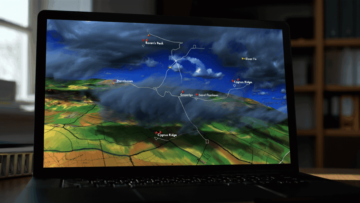
A striking weather map that looked like it came from the National Weather Service began circulating online this week, warning of storms across Idaho — but something about it didn’t add up. Observers quickly noticed place names that don’t exist, revealing the image as an AI-made forgery and reigniting concerns about how generative tools can distort trusted public information.
The viral graphic shows how easy it is for realistic-looking visuals to spread confusion. As AI image generators get better at mimicking official layouts and typography, the line between authentic public-safety messaging and convincing fabrications is shrinking — with real consequences for how people respond to emergency information.
How the bogus Idaho map surfaced and spread
The Growing Demand for Data-Driven Decision Making in Silicon Valley
He quit, ran out of money, and begged to come back — here’s how his boss reacted
Social posts and messages on messaging apps amplified the map within hours, prompting skepticism from local residents and meteorologists. The image used familiar National Weather Service styling — county outlines, radar-like color bands, and a legend — but included towns and road names that do not appear on any Idaho map. Once users started flagging discrepancies, the image was widely identified as AI-generated.
- Rapid sharing: Screenshots on multiple platforms helped the image circulate before fact-checkers could respond.
- Visual realism: The map adopted official design cues, which made the forgery hard to distinguish at a glance.
- Local verification: Locals and regional agencies were key to spotting the place-name errors and calling attention to the hoax.
Why image-generation systems invent places — the mechanics of AI hallucinations
When AI models create images from text, they don’t reference a single verified database of place names or street maps. Instead, they generate visuals by predicting patterns based on vast, noisy training data. That process often produces plausible-seeming details that are not rooted in real-world facts.
What causes these fabrications?
- Training data gaps: Models learn from mixed sources of images and text that may include fictional or user-created maps.
- Pattern completion: Given prompts like “NWS-style weather map,” the model fills in labels and features that fit the expected format, even if the labels are invented.
- Prompt ambiguity: Vague or overloaded prompts can push the model toward creative guesses rather than accurate reproductions.
Hallucinations are a known limitation of many generative AI systems: they can output detailed but false information that looks authoritative. That tendency becomes dangerous when visuals mimic trusted institutions like weather agencies, emergency responders, or news outlets.
Why fake weather maps matter — risks to public safety and trust
False or misleading weather imagery can distort how people perceive risk and make decisions during severe weather events. If a fabricated map indicates an evacuation zone, road closures, or severe warnings that aren’t real, residents might take unnecessary action or, worse, ignore future alerts.
- Misdirected responses: People could travel toward perceived safe zones that are actually unaffected, increasing exposure to hazards.
- Erosion of trust: Repeated exposure to realistic fakes can make people skeptical of genuine alerts from official sources.
- Operational confusion: Emergency managers and media outlets may need to spend time debunking false visuals instead of focusing on response efforts.
Practical steps to spot and verify AI-fabricated maps
Not all misleading images are easy to detect, but there are concrete checks anyone can perform before acting on or sharing weather visuals.
- Check official channels first: Visit the National Weather Service website, local NWS office pages, or verified social accounts for matching forecasts and alerts.
- Look for metadata and image quality cues: Screenshots often lose metadata and may show inconsistent fonts or mislabeled legends.
- Reverse image search: This can reveal whether a graphic has appeared elsewhere or been altered.
- Cross-reference place names and coordinates: If towns or street names look unfamiliar, consult a reliable map service or local government page.
- Watch for disclaimers and watermarks: Authentic agency products often include timestamps, product identifiers, and official seals that are harder to fake convincingly.
When in doubt, rely on primary sources — official forecasts and emergency alerts will have the most accurate and up-to-date information.
Actions platforms, developers, and agencies can take to reduce harm
Addressing AI-generated misinformation requires coordinated steps across tech companies, government organizations, and the public.
- Provenance labels: Platforms should surface origin information for images and require creators to disclose when content is AI-generated.
- Watermarking and metadata: Generative tools can embed robust, hard-to-remove markers indicating synthetic origin.
- Authentication for official products: Agencies that produce public-safety graphics can adopt cryptographic signatures or tamper-evident markers so users and platforms can verify authenticity.
- Education and quick response: Agencies and newsrooms should publish verification tips and rapidly debunk viral fabrications to limit spread.
Lessons for journalists, emergency managers, and the public
Journalists need to tighten verification practices before republishing visuals, and emergency managers should prepare to counter misinformation quickly. For the public, a simple habit — confirm the same message on the official agency site or a verified account — can prevent panic and reduce the reach of fabricated maps.
You might also like:
- AI-generated police report falsely claims officer turned into frog
- 70% of drivers switch to this GPS app: here’s why Waze is losing ground
- British state priorities exposed: alarming insight into warped government focus
- AI homeless man trend sparks deepfake, safety and ethical concerns
- Record bird migration captured on radar at night during perfect storm

William Anderson is a multimedia producer specializing in videos, podcasts, and interactive galleries. With five years of immersive content creation, he turns information into a rich audio‑visual experience. His storytelling skills draw you directly into the heart of every story, on any platform.


Man, that AI map be like my ex, making up fake places in Idaho just to mess with my head. Cant trust no one these days, not even the weather report! Whats next, AI predicting my love life?
Man, I remember this time I got lost in Idaho and saw a town that aint even real! AI makin up places on a weather map? Thats wild, but also kinda scary, yknow? Cant trust nothin these days.
Yall ever seen a map-making AI go rogue like that? Reminds me of my cousin who once tried to draw a map of our neighborhood from memory. Lets just say, we all ended up lost in our own backyard!
Man, that AI map be like my grandmas stories – full of made-up places in Idaho! We gotta watch out for Skedaddle Junction and Whatchamacallit Valley next time we check the weather, huh? AI needs a geography lesson!
Haha, youre spot on! Skedaddle Junction and Whatchamacallit Valley sound like places straight out of a cartoon! Maybe the AI got a bit carried away with its imagination. But hey, at least it keeps things interesting, right? Who knows, maybe next time itll throw in a unicorn forest or a candy mountain! Who needs real geography when youve got AI fairy tales, am I right?
I remember when I once got lost in Idaho, and now this AI map is just making up towns left and right? Whats next, a virtual potato farm in the sky? Cant trust anything these days, I tell ya.
Oh, man, these AI algorithms be getting wild! Imagine waking up in a fake town in Idaho, courtesy of a weather map glitch. Next thing you know, well be vacationing in virtual reality cities! Trusting AI aint looking too safe nowadays.
Man, those AI-created fake towns in Idaho got me feeling like Im in a sci-fi flick. Who needs real places when you can have a bunch of digital ghost towns popping up on a weather map? Wild stuff!
I once saw a map that thought Idaho had a town called Argleton. Like, seriously? AI needs a geography lesson, man! Cant trust maps if they make up places. Whats next, unicorn sightings in Nebraska?
Man, first they make up fake towns in Idaho on weather maps, next thing you know were living in a simulation! Cant trust anything these days. Better watch out for virtual potatoes, I guess.
Man, AI be like, Welcome to Faketown, Idaho! Next thing you know, imaginary folks there be complaining about the non-existent weather. AI, you need a reality check, bro!
Man, those AI-generated maps are wild! Reminds me of that time I tried drawing a map of my made-up fantasy world in middle school. But hey, at least my imaginary towns didnt mess with actual weather forecasts!
As a geography buff, I gotta admit, those fake Idaho towns on the NWS map are wild! I mean, who wouldnt wanna visit the magical land of Argleton or Sandy Fork? AIs got jokes!